


The Ganges is a major river in South Asia, flowing through northern India and Bangladesh. With a total length of 2,525 kilometers and a basin area of 910,000 square kilometers, covering one-third of India’s land area. The Ganges ranks among the world’s top 20 rivers in terms of water flow, and the Ganges basin is the most densely populated river basin globally, housing over 400 million people and boasting a population density exceeding 390 people per square kilometer.
Despite its significance, large ships are rarely seen on the Ganges, India’s largest river. In contrast, China’s largest river, the Yangtze River, features over 71,000 kilometers of navigable waterways, annually serving 184 million passengers and transporting 4.714 billion tons of cargo.
Nestled in the densely populated and urbanized plains of northeastern India, the question arises: why is navigation virtually nonexistent on the Ganges River, despite its ample width and resources?
Situated at the rear of the Asian continent, the entire Indian Peninsula extends southward into the Indian Ocean, rendering India profoundly influenced by the interplay of land and sea and shaping its tropical monsoon climate.
During summer, the barometric pressure belt shifts, driving the wind belt northward and pushing the equatorial low pressure to the northern hemisphere. The southeast trade winds then sweep northward toward the Indian Peninsula, where they morph into southwesterly winds, laden with moisture from the Indian Ocean. These winds blanket the entire peninsula, triggering substantial precipitation, particularly along the south slopes of the Himalayas where precipitation is amplified due to blocking effects.
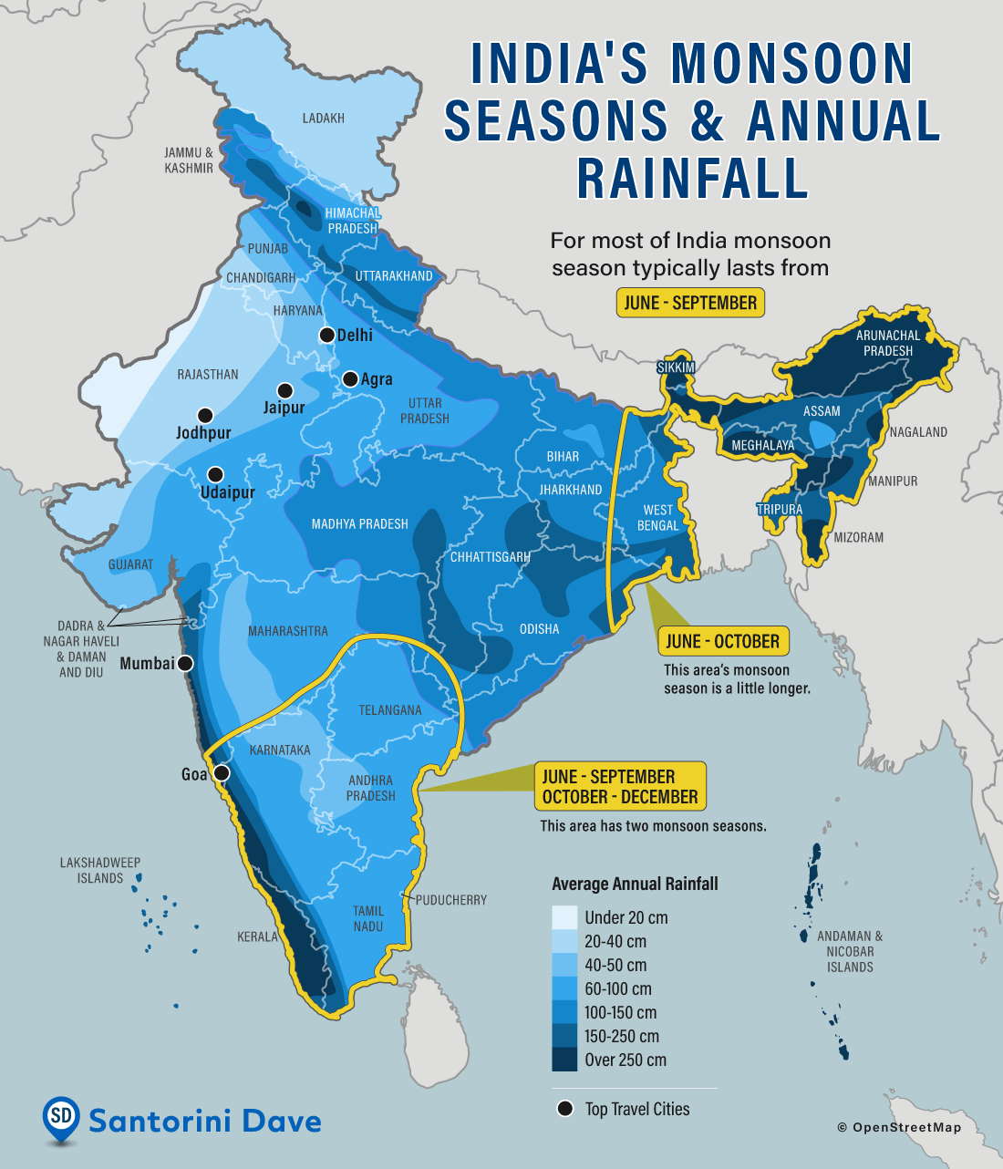
Conversely, winter witnesses the reversal of these atmospheric dynamics. The pressure belts and wind patterns shift southward, with the equatorial low pressure belt migrating to the southern hemisphere. The Asian continent experiences the dominance of cold high pressure systems, causing winds to blow from Mongolia and Siberia towards India, deflecting into northeast winds. These winds, originating from the northern inland regions, carry significantly less moisture, resulting in markedly reduced winter precipitation compared to summer.
Influenced by the tropical monsoon climate, the Ganges River Basin experiences two distinct precipitation seasons: the rainy season, concentrated from July to October, marks the flood season of the Ganges River, with its water volume comprising 82% of the annual total. In contrast, the remaining eight months constitute the dry season, during which the Ganges River’s water volume dwindles to a mere 18% of the total annual volume. The stability of river water is crucial for the development of navigation within a river system. The Rhine River serves as a prime example of a “golden waterway” enabled by consistent precipitation throughout the year within a temperate maritime climate.
However, the Ganges River presents a different scenario, characterized by drying up in times of drought and flooding in times of excessive rainfall. This erratic behavior results in high navigational value during periods of ample water flow, while the value diminishes significantly during low-water periods, which can persist for up to eight months.
Is there a viable man-made solution to this dilemma? Indeed, constructing reservoirs offers a potential remedy for regulating river water volume. The Yangtze River, situated in a similar monsoon climate zone, provides a compelling example. China has erected 284 large reservoirs and 1529 medium-sized reservoirs along the Yangtze River’s tributaries. These reservoirs serve not only for power generation but also for flood mitigation and water release during dry periods. By strategically controlling water levels—closing gates during flood seasons and opening them during dry periods—the Yangtze River effectively counters the challenges posed by the monsoon climate, ensuring consistent water levels year-round and facilitating uninterrupted ship passage.
However, a direct application of this solution to the Ganges River basin proves unfeasible when considering the differing climate and topography of India.
The Ganges River faces additional challenges due to high sedimentation and its relatively flat terrain. Flowing from northwest to southeast, the Ganges Plain provides a flat and open backdrop to the river.
Considering the period of continental drift, the collision between the Indian Ocean plate and the Eurasian continental plate resulted in the formation of the towering Himalayas. Simultaneously, structural subsidence in the southern foothills of the Himalayas created numerous troughs gradually filled by the alluvial action of the Indus and Ganges Rivers, ultimately forming the present-day Indus-Ganges Plain. Geologically categorized as a pre abyssal or foreland basin, the Indus-Ganges Plain is flatter than the average plain.
Unlike the Yangtze River, where reservoirs are mostly constructed in upstream areas with steep terrain to regulate water levels downstream, the situation along the Ganges River poses unique challenges. The mainstream traverses the Great Plains, characterized by minimal elevation changes and densely populated areas.
The construction of reservoirs in such regions would inundate vast areas, posing significant resettlement costs beyond governmental capacities. The northern tributaries, flowing through the southern slopes of the Himalayas, feature steep slopes and narrow canyons, rendering large reservoir construction impractical. Similarly, the southern tributaries, mainly traversing the Deccan plateau, despite gentler slopes compared to the southern Himalayan slopes, receive average precipitation levels, diminishing the effectiveness of reservoir construction in regulating the main stream’s water levels. Moreover, these areas are densely populated, further complicating large-scale reservoir projects.
Consequently, only Nepal has attempted to construct small reservoirs along the Ganges River tributaries. However, their combined capacity of 28 billion cubic meters pales in comparison to the Ganges River’s annual runoff, exceeding 550 billion cubic meters. Additionally, the immense sediment load poses a significant hindrance to reservoir construction. The Ganges River annually loses 1.451 billion tons of sand, surpassing that of the Yangtze River threefold and even exceeding the renowned sediment-rich Yellow River by sevenfold. The likelihood of sedimentation rapidly filling any constructed reservoir is thus considerable.
Furthermore, the Ganges River’s excessively flat topography results in a significantly slower average flow rate of 12,000 cubic meters per second in the middle and lower reaches, far lower than the Yangtze River’s average of 28,800 cubic meters per second. The river’s wide and shallow channels further exacerbate navigation challenges, as deeper-draft vessels are prone to grounding.
Moreover, the absence of an estuary and the Ganges River’s location far from international shipping lanes in the Bay of Bengal discourage maritime traffic. In contrast, China’s Yangshan Port and Zhoushan Port lie along major international shipping routes, facilitating convenient access for ships from various countries.
Lastly, the widespread adoption of rail transportation, dating back to the British colonial era, has supplanted river transport along the Ganges. The extensive railway network spanning over 50,000 kilometers efficiently connects various regions, rendering river transport obsolete. Additionally, historical bridge construction over the Ganges, characterized by low bridge heights relative to the river level, further deters large-scale shipping development. Even today, makeshift pontoon bridges are erected near permanent bridges to alleviate traffic congestion, further underscoring the limited navigational capacity of the Ganges.
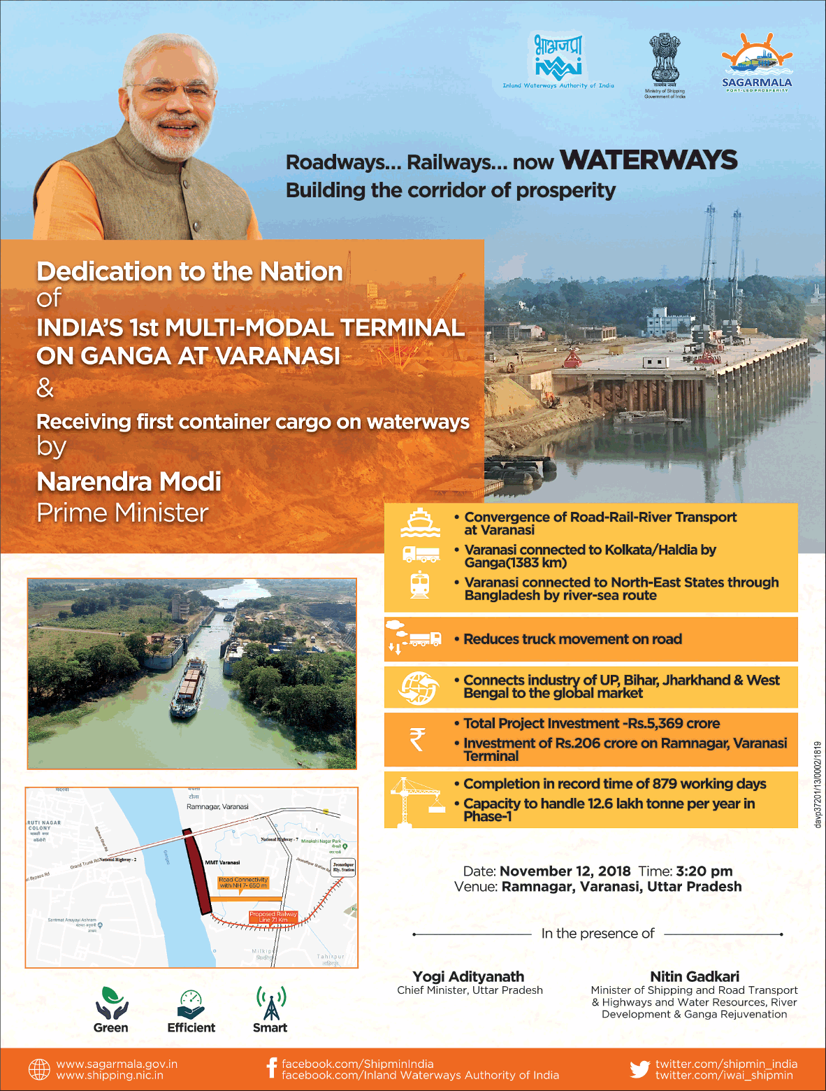
Despite these challenges, the Indian government has taken proactive steps to enhance the Ganges’ shipping capacity. Initiatives such as the Jal Marg Vikas Project, launched in 2014 with support from the World Bank, aim to upgrade the Ganges as National Waterway No. 1. This ambitious plan involves constructing inland multimodal terminals to accommodate vessels weighing 1,500-2,000 tons. The successful inauguration of India’s first inland navigation terminal, Varanasi Port, in December 2018 marks a significant milestone, reintroducing inland container transportation after 70 years of independence.
Source: Advert Gallery, Santorini Dave, Flickr